
Salva Martínez nos presenta Portolan, nuestro nuevo model-driven cartography framework (para más detalles ver el research report o la herramienta en Eclipse labs).
Os dejo con la explicación de Salva:
Processing large amounts of data to extract useful information is an essential task within companies. To help in this task, visualization techniques have been commonly used due to their capacity to present data in synthesized views, easier to understand and manage.
However, achieving the right visualization display for a data set is a complex cartography process that involves several transformation steps to adapt the (domain) data to the (visualization) data format expected by visualization tools.
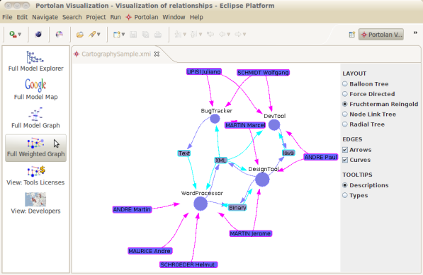
To maximize the benefits of visualization we propose Portolan, a generic model-driven cartography framework that facilitates the discovery of the data to visualize, the specification of view definitions for that data and the transformations to bridge the gap with the visualization tools (like google maps or prefuse).
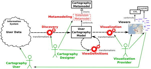
The cartography process proposed by the Portolan framework is composed by four high level tasks identified during our experiments on three different use cases:
- Metamodeling: analysis of the domain, to capture its concepts and define corresponding types;
- Discovery: collect user’s DATA, transform AND merge them INTO a central model;
- VIEW Definition: design transformations TO filter OR compute subsets OF the central model;
- Visualization: pass the central model (OR a subset OF it) TO viewers, IN order TO GET a graphical display OF USER’s data.
Then, the Portolan platform aims at facilitating this process by providing a set of Model-Driven tools to bridge the gap between a given (data) domain and the visualization world, with respect to the four Cartography tasks presented above.
Concretely, the platform provides:
- a set of default DSLs like GraphML, KML, Excel;
- visual displays based on Prefuse, Google Maps;
- modeling tools such as ATL language, Ecore modeler, etc.
All these provided features are integrated within extension mechanisms in order to apply each feature to different domains and be able to plug in Portolan other viewers and cartography tools.
Si te ha gustado esta entrada, puedes subscribirte a este Software Modeling blog, a la lista de distribución del portal , seguirme en twitter , participar en el foro y/o leer los posts más poopulares . Y si realmente te ha gustado ayúdame a hacerlo llegar a otros utilizando los servicios que tienes a continuación. No olvides mirar también nuestros servicios de consultoría y generación de código
FNR Pearl Chair. Head of the Software Engineering RDI Unit at LIST. Affiliate Professor at University of Luxembourg. More about me.

Recent Comments